

Innovation is one of 4 key themes within Ofwat’s Price Review 19 (PR19), which address the future challenges that the water industry is facing and examples of water companies innovating to solve costly challenges are already emerging at a pace.
A recent case in point has been Thames Water’s response to the problem of fatbergs – a challenge which, along with other blockages in its network, costs up to £1m a month according to their corporate blog1. To tackle fatbergs, Thames have gone straight to the primary cause of the problem, deploying a team of investigators2 to visit food businesses across their catchment. The team investigate reports of sewer misuse and carry out an onsite survey to determine compliance. During a 9 month pilot they found that that 90% of food businesses visited did not have adequate grease management in place and are not aware that they should.
The Investigators use easily deployed mobile apps provisioned from Thames Water’s Geographical Information Systems (GIS) platform, which also provides a real-time view of the progress of the operation to be monitored centrally. Work can be allocated and managed centrally and all information kept in one location, this creates an invaluable real time link with the field team. The apps capture the location of each business surveyed, which in turn allows visualisation on an operations dashboard incorporating a map, and spatial analytics to further investigate the extent of the problem.
Leaving challenges like fatbergs aside for a moment, the same GIS capabilities enable innovative water utilities to collect, maintain and share asset information more accurately and in near real-time. Severn Trent Water3, for example, was determined to enhance the quality of its asset data and took the decision to completely transform its approach to data collection and verification. The company had previously digitised its records of underground water mains and sewers, back in 2000. However, for decades beforehand, it had relied on paper-based asset maps updated by hand. As the original paper-based records weren’t that precise, many of the digital records didn’t have the accuracy and completeness that were needed.
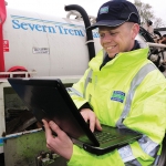 Severn Trent Water is systematically improving the quality of its asset data using a mobile GIS solution from Esri UK. With more complete and accurate records, it can deliver better customer services, optimise its business performance and operate more efficiently. Updates made in the field by mobile engineers are immediately visible to all the company’s 4,500 employees. Improved data leads to better decision making, faster resolution of service issues and less disruption for the public. In terms of PR19, that improved decision making, faster resolution of service issues and minimised disruption is contributing to Severn Trent Water’s household customers continuing to receive the lowest average combined water and sewerage bills in England and Wales.
In fact, asset management is a critical business priority for water utilities because there is a direct correlation between asset failures and service failures which, inevitably, lead to poor customer satisfaction. The industry regulator Ofwat monitors service performance very closely and has made it a central theme of PR19 . It is therefore imperative for water utilities to have accurate, complete asset data, so that they can repair asset defects quickly, as well as invest wisely in asset replacement programmes to reduce the risk and frequency of service issues. The rapid deployment and flexibility of GIS apps, the analytical capabilities and the ability to provide intuitive, interactive operational dashboards for key stakeholders is delivering significant advantages for water companies throughout the UK.
Another industry innovator is Wessex Water4, a company that is consistently among the top scoring water businesses for customer service because they are constantly looking for new and creative ways to improve their customer communications. The company publishes an interactive online map to share accurate, up-to-date information about planned and emergency works currently taking place throughout their region. The map includes features such as live chat buttons, which enable customers to connect easily with customer service agents from within the map. In addition, where there are temporary water service interruptions, engineers in the field use their mobile devices to draw polygons around the relevant streets. A list of customers’ mobile numbers is then automatically extracted by Esri derived client software, enabling the customer service team to quickly send out a timely text-based message to all households affected by the works. In the customer call centre, Esri’s Operations Dashboard is used to improve communications by providing an up-to-the-minute graphical overview of incidents on huge wall-mounted, smart screens. The dashboard is also available via the organisation’s intranet, so in the event of an emergency, it is possible to make this real-time operational information available to managers on any internet-connected device. One impact of these innovations is that the company has seen a 20% fall in calls to the customer service unit reporting problems with ‘no water’.
If you are looking to improve asset management, find innovative solutions to challenges like fatbergs or want to deliver exceptional customer service then GIS technology provides a cost effective, proven range of capabilities. Esri UK can provide a full range of support, implementation and configuration services to ensure success and a strong return on investment.
For more information please contact us using sales@esriuk.com, 01296 745599 or visit
esriuk.com/water to explore how you could put GIS to work.
1. https://corporate.thameswater.co.uk/Media/News-releases/Whitechapel-Road-Thames-Water-wins-battle-but-fatberg-war-continues
2. https://corporate.thameswater.co.uk/Media/News-releases/Fatbergs-feeding-off-London-food-outlets
3. https://resource.esriuk.com/severn-trent-water-utilities/
4. https://resource.esriuk.com/wessex-water/


