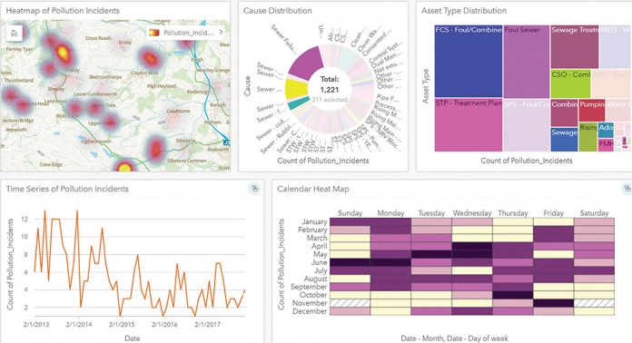
Business intelligence delivered through geographic information systems (GIS) is helping water companies throughout the UK make significant improvements across operations, both in the office and out in the field. Location is the common denominator that connects disparate data and resources, providing utilities with insight and a timely understanding of their, incidents, infrastructure, resources and customers.
Water companies are extending their field operations with applications that incorporate geographical context. These applications are revolutionising traditional processes and enabling new possibilities to improve collaboration between colleagues in the office and those out in the field, who are planning and delivering work. The same information can be accessed by anyone, anywhere on any device, allowing more robust, timely, evidence-based decisions to be made.
One company leading the field in the provision of GIS is Esri, the largest provider of GIS systems in the world. In the UK alone, 80% of the water industry use Esri software capabilities, whilst across the globe, over 9,000 water utility companies utilise their mapping, visualisation and analytics tools.
“With a wide range of applications, Esri software can be simply configured to help plan targeted work, so resources are directed where they’re needed most, in turn driving business efficiency improvements,” explains Craig Hayes, Head of Critical National infrastructure at Esri.
“Tabular data in a spreadsheet simply can’t enhance operations in the same way, as it doesn’t provide the spatial perspective critical to maintaining infrastructure networks. This can only be achieved through GIS. Esri provides this context through tools to support mapping and spatial reasoning, enabling resources with the capabilities required for the task, to be targeted where they’ll have the greatest impact.”
“Quickly, and at a relatively low cost, water companies can facilitate improved business outcomes by using Esri software. Many facets of the water industry can be improved, from monitoring water quality to incident management, environmental management, maintenance scheduling, managing field operations and long-term investment plans.”
Customers can be served better too, as water companies can harness real-time information to provide timely service updates about what is going on around the network, when and where.
Behavioural change can also be brought about with Esri software. A good case in point is Thames Water, who utilised Esri solutions to tackle their costly fatberg crisis. Every year around 80,000 blockages are cleared from its underground sewerage network, 40% of which are caused by congealed fat, oil and grease (FOG). The blockages cost Thames Water around £1 million a month to clear, so preventing these blockages from forming was a priority.
Investigations indicated that a significant proportion of the FOG waste in Thames Water’s network was emanating from 43,000 restaurants and food retailers in and around London and the Thames Valley. As a result, an education programme was launched to make these food businesses aware of their legal obligations and to encourage them to dispose of their FOG more responsibly. Ensuring a consistent approach, collecting supporting data and monitoring the progress of this programme was vital – but how could this best be achieved?
A complete, end-to-end process was created using Esri’s out-of-the box-functionality. The locations of fatbergs and flooding incidents were analysed, identifying hotspots to target education initiatives. Investigators made initial and follow-up appointments, using Esri’s mobile applications to record their visits; while back in the office, holistic progress was analysed using Esri’s Operations Dashboard.
The efficient collection of accurate data has yielded promising results, increasing the adoption of correct FOG disposal practices, with reductions in sewer clearance costs anticipated, despite the programme being in its early days.
Thames Water’s not alone in realising the benefits of ArcGIS in bringing about behavioural change. Anglian Water has also employed the software in its ‘Keep it Clear’ campaign to help prevent sewer blockages.
Together these programmes are enabling water companies to deliver a more robust infrastructure through focussed preventative work. All in all, the rich geographical information and off the shelf capabilities provided by Esri allows water companies to identify emerging problems quickly and to mitigate for more serious problems that could arise. Customers benefit from a better service and business improvements are galvanised.
Visit esriuk.com/field-operations or contact Craig Hayes, Head of Critical National Infrastructure for Esri UK on 01296 745599 or sales@esriuk.com


